Cooler temperatures and showers are characterizing a dreary summer Friday and providing some relief after a scorching heat wave in the D.C. region.
Wet weather is soaking parts of the D.C. region Friday afternoon.
“Clouds win over sunshine for the remainder of the afternoon with scattered showers, even a few rumbles of thunder,” said 7 News First Alert Meteorologist Steve Rudin.
A flood warning is in effect until 5:30 p.m. for Manassas, Manassas Park and Prince William County amid heavy rainfall in Northern Virginia, according to the National Weather Service.
- Listen to WTOP online and on the radio at 103.5 FM or 107.7 FM.
- Current traffic conditions
- Weather forecast
- Closings and Delays
- Sign up for WTOP email alerts
- Get custom alerts with the WTOP app for Apple and Android phones
The highest chance for storms is west of D.C.
“A few storms are possible in the mountains and if they hold together they may work their way across the metro area and into the overnight,” 7News First Alert Senior Meteorologist Brian van de Graaff said.
An end to the first heat wave of 2025
Meanwhile, Rudin said temperatures should stay in the 70s, which is far below average for this time of year.
The weather marks a stark difference from the feels-like readings of 100 degrees that were reported during the peak of the heat dome at the start of the week.
“Our five day stretch of high heat has finally broken,” said 7News First Alert Senior Meteorologist Brian van de Graaff.
While the mid-70s temperatures are more manageable, van de Graaff said there’s still a chance for “lots of mugginess in the air.”
Looking ahead to the weekend, Saturday will be in the 90s with less humidity, dipping into the mid-70s after sunset. Storms in the afternoon also pose a threat to the already-saturated ground, although it doesn’t seem like they’ll cause a complete washout.
Sunday will be similar to Saturday, with partly cloudy skies and the stray thunderstorm possible in the afternoon. Highs will be in the upper 80s nearing 90 degrees, and cooling into the low 70s with light winds by nightfall.
Thursday’s storms leave Md. homes damaged
Several homes were left with varying degrees of damage late Thursday, leaving many displaced in the Greenwood Knolls neighborhood of Silver Spring, Maryland.


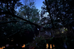
Montgomery County Fire and EMS spokesman Pete Piringer said in a statement that downed trees prompted significant damages to homes along Valleywood Drive.
Footage shared by Piringer shows trees collapsed on roofs and rear balconies.
No injuries were reported.
Forecast
FRIDAY EVENING:
Scattered showers. Thunder
Temperatures: 70s
Winds: East 5-10 mp
FRIDAY NIGHT:
Mostly cloudy. Showers. Isolated thunderstorms
Lows: 68-74
Winds: Light Easterly
SATURDAY:
Partly to mostly sunny. Pop-up afternoon storms
Highs: 88-93
Winds: Southwest 5-10 mph
SUNDAY:
Partly cloudy. Isolated storms
Highs: near 90
Winds: Northwest 5-10 mph
Current conditions
WTOP’s Jessica Kronzer contributed to this report.
Get breaking news and daily headlines delivered to your email inbox by signing up here.
© 2025 WTOP. All Rights Reserved. This website is not intended for users located within the European Economic Area.