Thunderstorms capped off days of brutal high temperatures that’s been gripping the D.C. area. But will the storms bring a cool reprieve from the scorching heat? Here’s what you need to know.
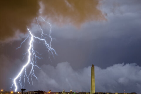
Severe thunderstorms started to sweep through the area, incuding in Montgomery County in Maryland and Loudoun and Fairfax counties in Virginia on Wednesday afternoon.
Ground stops were called to BWI Marshall and Dulles International airports as storms passed by.
The National Weather Service said damaging winds may cause some trees and large branches to fall, as well as cause road blocks and power outages.
“It will feel like we’re up around 108 degrees during the afternoon,” 7News First Alert Chief Veronica Johnson said.
Tuesday was the hottest day of the year so far, breaking records in Baltimore and at Reagan National Airport in Arlington.
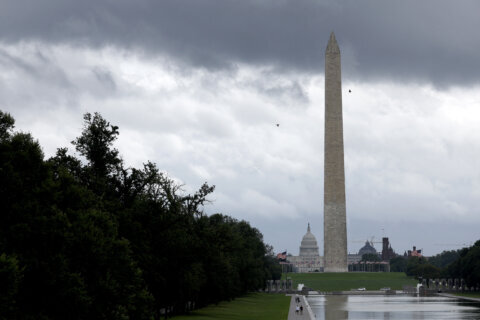
Washington Monument remains closed
The Washington Monument was closed Wednesday, according to the National Park Service.
Mike Litterst with the National Park Service told WTOP on Tuesday that the decision to close the monument was for the safety of visitors and staff.
While there is air conditioning at the lookout point, Litterst said it is hard for it to keep up when the weather conditions are very hot.
“We want to caution all of our visitors to plan accordingly and be smart,” Litterst said. “Make sure that you hydrate. Bring water with you; bring snacks so that you don’t dehydrate.”
Forecast
Mike Stinneford, WTOP Meteorologist
WEDNESDAY EVENING: HEAT ALERT
Hot and humid with scattered thunderstorms. Storms may produce damaging winds, large hail and isolated tornadoes.
WEDNESDAY NIGHT:
A chance of showers and thunderstorms before midnight. Warm and muggy overnight. Lows in the 70s to around 80
THURSDAY:
Partly sunny, hot and humid with afternoon thunderstorms. Storms may produce damaging winds, large hail and isolated tornadoes. Rain heavy at times. Highs in the low to mid 90s
FRIDAY:
Partly cloudy and cooler. An isolated storm is possible. Highs upper 70s to mid 80s
SATURDAY AND SUNDAY:
Afternoon showers and thunderstorms. Highs upper 80s to lower 90s
Current conditions
Get breaking news and daily headlines delivered to your email inbox by signing up here.
© 2025 WTOP. All Rights Reserved. This website is not intended for users located within the European Economic Area.