Listen live to WTOP online and on 103.5 FM for traffic and weather updates on the 8s.
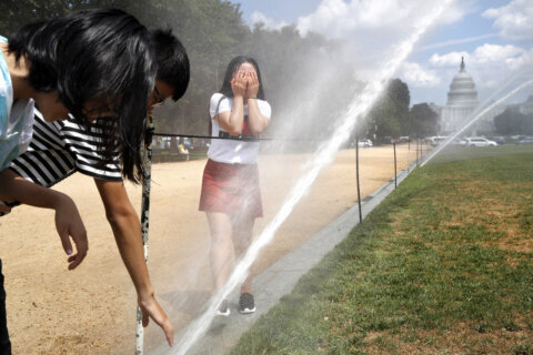
The D.C. region will continue to trudge through its first heat wave of the summer, though Wednesday brings chances of showers and thunderstorms.
“We have a heat advisory, which will be a downgrade from the heat warning that we had (Tuesday), mid-90s to around 100, but it feels like temperatures will be 100 to 105,” said 7News First Alert Meteorologist Steve Rudin.
There will also be a good chance for showers or thunderstorms in the afternoon and evening on Wednesday, Rudin, said
As a result of the heat dome over much of the Midwest and East Coast, Baltimore Gas and Electric called their customers and urged them to reduce energy consumption by raising thermostats and delaying the use of large appliances between 2 p.m. to 6 p.m.
Dominion Energy suggested customers set thermostats to 78 or higher when home and use fans to circulate air, close blinds and curtains during the hottest times of the day, run large home appliances during cooler evening hours, and unplug electronics when they are not being used in an effort to reduce unnecessary heat and energy waste.
High temperatures and humidity will stick around overnight in Wednesday, with lows in the upper 70s.
The National Weather Service has already issued an extreme heat warning for Wednesday, as temperatures are forecast to near 100, with a heat index between 100 and 105. It suggests drinking “plenty of fluids, stay in an air-conditioned room, stay out of the sun, and check up on relatives and neighbors.”
Temperatures may relax slightly Thursday, as highs are forecast between 93 and 97, with a heat index between 99 and 102.
Friday will bring a needed break in the extreme heat, with highs in the 80s and lower humidity.
Washington Monument remains closed
The Washington Monument will remain closed on Wednesday due to the extreme heat warning.
Mike Litterst with the National Park Service told WTOP that the decision to close the monument was for the safety of visitors and staff. The closure includes the elevator to the top and the stone plaza surrounding the 555-foot-tall marble obelisk. The grass grounds surrounding the monument will remain open.
While there is air conditioning at the lookout point, Litterst said it is hard for it to keep up when the weather conditions are very hot.
“We want to caution all of our visitors to plan accordingly and be smart,” Litterst said. “Make sure that you hydrate. Bring water with you; bring snacks so that you don’t dehydrate.”
- Listen to WTOP online and on the radio at 103.5 FM or 107.7 FM.
- Current traffic conditions
- Weather forecast
- Closings and Delays
- Sign up for WTOP email alerts
- Get custom alerts with the WTOP app for Apple and Android phones
7News First Alert Forecast
EVENING:
Mostly Sunny
Temperatures: 85-91
Heat Index: 100-110
Winds: Southwest 5-10 mph
Extreme heat continues into the early evening. An extreme heat warning remains active for most of the DMV until 9 p.m.
TONIGHT:
Mainly Clear
Lows: 77-82
Winds: Light
Another very warm and humid night is in store under mainly clear skies.
WEDNESDAY:
Partly Cloudy, PM T-Storms
Highs: 95-100
Heat Index: 100-108
Winds: Northwest 5 mph
Temperatures remain very high, but air temperatures may be a degree or two lower than Tuesday with the chance for a few pop-up showers and thunderstorms during the afternoon. The Storm Prediction Center has the DMV in the Level 1 out of 5 (Marginal) risk for severe storms that could contain damaging wind gusts. Outside of any storms, the heat will remain the big weather story. An extreme heat watch has been posted by the National Weather Service.
THURSDAY:
Sunny, Storm Possible
Highs: 90-95
Heat Index: 98-104
Winds: Northwest 5-10 mph
Temperatures begin to come down a few degrees as storm chances increase to 50% during the afternoon and evening. Widespread severe weather is not expected at this time.The Storm Prediction Center has the DMV in the Level 1 out of 5 (Marginal) risk for severe storms that could contain damaging wind gusts.
FRIDAY:
Partly Cloudy
Highs: 78-83
Winds: East 5-10 mph
Friday is set to bring a brief break from stifling heat and humidity. Plan for a day with highs around 80 under a mix of sun and clouds.
CURRENT CONDITIONS
WTOP’s Jessica Kronzer, Tadiwos Abedje, José Umaña, Matt Small and Jeffery Leon contributed to this report.
Get breaking news and daily headlines delivered to your email inbox by signing up here.
© 2025 WTOP. All Rights Reserved. This website is not intended for users located within the European Economic Area.